
New Mapping and Data from my truck


im about to geek out so get ready.
including the video that was included in my other thread, my Android phone features an App called My Tracks. It uses GPS to calculate your trips including distance and such. You can then overlay the info on a Google Map. Great if you are hitting trails and want to map out your run. My first test was i left the school i work at and went to a deli, that i call Dirty Dan's. It is pretty accurate as you can see it catches me making turns in the correct lanes. Here is the map.
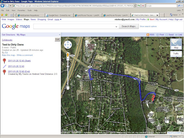
and here is the data that it automatically puts into a spreadsheet in Google Docs.
Name - 1/28/2011
Description -
Date - Fri Jan 28 12:40:00 EST 2011
Total Time - 00:11:56
Moving Time - 00:05:46
Distance - 1.55
Distance Unit - mi
Average Speed - 7.80
Average Moving Speed - 16.16
Max Speed - 35.90
Speed Unit - mi/h
Elevation Gain - 89.00
Min Elevation - 469.00
Max Elevation - 526.00
Elevation Unit - ft
the app runs in the background so i can still shoot videos on the trail and it also charges the phone when hooked up to the mount i bought.
including the video that was included in my other thread, my Android phone features an App called My Tracks. It uses GPS to calculate your trips including distance and such. You can then overlay the info on a Google Map. Great if you are hitting trails and want to map out your run. My first test was i left the school i work at and went to a deli, that i call Dirty Dan's. It is pretty accurate as you can see it catches me making turns in the correct lanes. Here is the map.
and here is the data that it automatically puts into a spreadsheet in Google Docs.
Name - 1/28/2011
Description -
Date - Fri Jan 28 12:40:00 EST 2011
Total Time - 00:11:56
Moving Time - 00:05:46
Distance - 1.55
Distance Unit - mi
Average Speed - 7.80
Average Moving Speed - 16.16
Max Speed - 35.90
Speed Unit - mi/h
Elevation Gain - 89.00
Min Elevation - 469.00
Max Elevation - 526.00
Elevation Unit - ft
the app runs in the background so i can still shoot videos on the trail and it also charges the phone when hooked up to the mount i bought.
Last edited by hilltoppersx; Jan 28, 2011 at 12:37 PM.


i can't speak for the iPhone because i never owned one but the google functionality is fantastic. the fact that everything is automatically synced with my online account and that it has baiscally an office suite that i can use on my phone or the computer, the mapping features same thing mobile or home is just amazing. my droid x the screen size is bigger than nearly every phone out so it works well as GPS and with an 8mp camera and HD video i don't need to carry anything else. The next phone im going to buy will be the droid x 2 which is going to be the same dimensions but faster with a better resolution and better camera.
anyway im really looking forward to using it at the pine barrens trip. to map our trail run and shoot some video.
anyway im really looking forward to using it at the pine barrens trip. to map our trail run and shoot some video.

 I second the car mount for the Droid being fantastic..
its part of Google Labs and it runs in the background so you can still use the GPS or camcorder.


send me that tab and ill have that **** hooked up! tell me when u r free so we can swap some stuff.
Recovery Vehicle
Joined: Feb 2009
Posts: 1,151
Likes: 30
From: Denver, CO
For the iPhone I think you can use Map My Ride. I use it for mountain biking, it also uses Google maps and has a pay and free version. Free version has all the capability I ever needed. On the iPhone4 I think it will run in the back ground as most apps will now.

Thread
Thread Starter
Forum
Replies
Last Post
sickws6
Discovery II
6
Nov 28, 2011 12:30 PM